 www.geodatenkatalog.de (S1L)
Keyword
Oceanographic geographical features
15 record(s)
Provided by
Type of resources
Topics
Keywords
Contact for the resource
Update frequencies
-
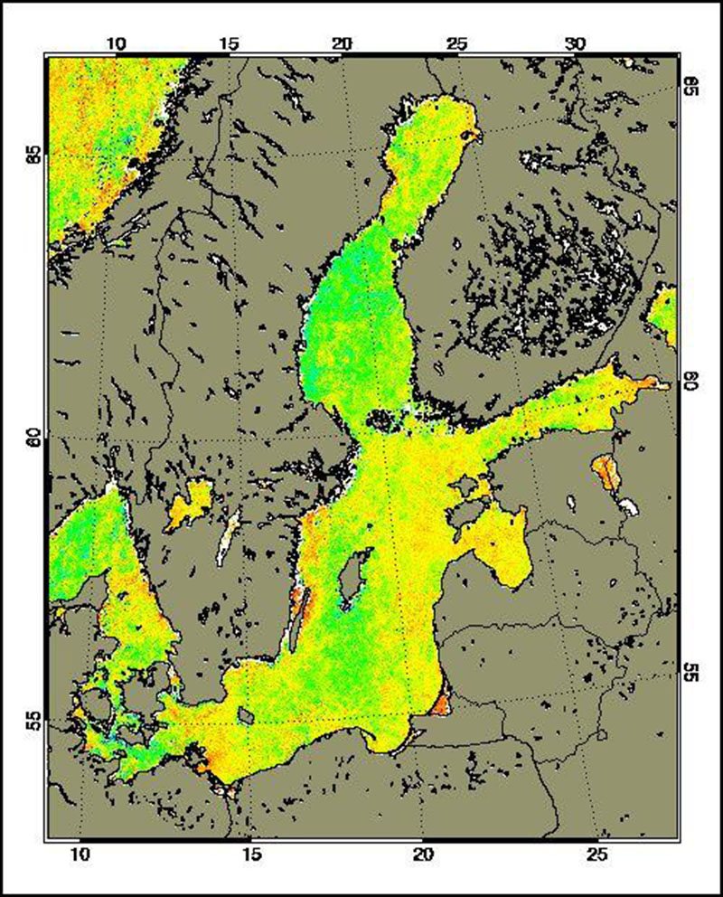
The Medium Resolution Imaging Spectrometer (MERIS) on Board ESA’s ENVISAT provides spectral high resolution image data in the visible-near infrared spectral region (412-900 nm) at a spatial resolution of 300 m. For more details on ENVISAT and MERIS see http://envisat.esa.int/ Spectral high resolution measurements allow to assess different water constituents in optically complex case-2 waters (IOCCG, 2000). The main groups of constituents are Chlorophyll, corresponding to living phytoplankton, suspended minerals or sediments and dissolved organic matter. They are characterised by their specific inherent optical properties, in particular scattering and absorption spectra. The Baltic Sea Water Constituents product was developed in a co-operative effort of DLR (Remote Sensing Technology Institute IMF, German Remote Sensing Data Centre DFD), Brockmann Consult (BC) and Baltic Sea Research Institute (IOW) in the frame of the MAPP project (MERIS Application and Regional Products Projects). The data are processed on a regular (daily) basis using ESA standard Level-1 and -2 data as input and producing regional specific value added Level-3 products. The regular data reception is realised at DFD ground station in Neustrelitz. For more details the reader is referred to http://wdc.dlr.de/sensors/meris/ and http://wdc.dlr.de/sensors/meris/documents/Mapp_ATBD_final_i3r0dez2001.pdf This product provides 10-day maps.
-

The Medium Resolution Imaging Spectrometer (MERIS) on Board ESA’s ENVISAT provides spectral high resolution image data in the visible-near infrared spectral region (412-900 nm) at a spatial resolution of 300 m. For more details on ENVISAT and MERIS see http://envisat.esa.int/ Spectral high resolution measurements allow to assess different water constituents in optically complex case-2 waters (IOCCG, 2000). The main groups of constituents are Chlorophyll, corresponding to living phytoplankton, suspended minerals or sediments and dissolved organic matter. They are characterised by their specific inherent optical properties, in particular scattering and absorption spectra. The Baltic Sea Water Constituents product was developed in a co-operative effort of DLR (Remote Sensing Technology Institute IMF, German Remote Sensing Data Centre DFD), Brockmann Consult (BC) and Baltic Sea Research Institute (IOW) in the frame of the MAPP project (MERIS Application and Regional Products Projects). The data are processed on a regular (daily) basis using ESA standard Level-1 and -2 data as input and producing regional specific value added Level-3 products. The regular data reception is realised at DFD ground station in Neustrelitz. For more details the reader is referred to http://wdc.dlr.de/sensors/meris/ and http://wdc.dlr.de/sensors/meris/documents/Mapp_ATBD_final_i3r0dez2001.pdf This product provides monthly maps.
-

The Medium Resolution Imaging Spectrometer (MERIS) on Board ESA’s ENVISAT provides spectral high resolution image data in the visible-near infrared spectral region (412-900 nm) at a spatial resolution of 300 m. For more details on ENVISAT and MERIS see http://envisat.esa.int/ Spectral high resolution measurements allow to assess different water constituents in optically complex case-2 waters (IOCCG, 2000). The main groups of constituents are Chlorophyll, corresponding to living phytoplankton, suspended minerals or sediments and dissolved organic matter. They are characterised by their specific inherent optical properties, in particular scattering and absorption spectra. The Baltic Sea Water Constituents product was developed in a co-operative effort of DLR (Remote Sensing Technology Institute IMF, German Remote Sensing Data Centre DFD), Brockmann Consult (BC) and Baltic Sea Research Institute (IOW) in the frame of the MAPP project (MERIS Application and Regional Products Projects). The data are processed on a regular (daily) basis using ESA standard Level-1 and -2 data as input and producing regional specific value added Level-3 products. The regular data reception is realised at DFD ground station in Neustrelitz. For more details the reader is referred to http://wdc.dlr.de/sensors/meris/ and http://wdc.dlr.de/sensors/meris/documents/Mapp_ATBD_final_i3r0dez2001.pdf This product provides daily maps.
-
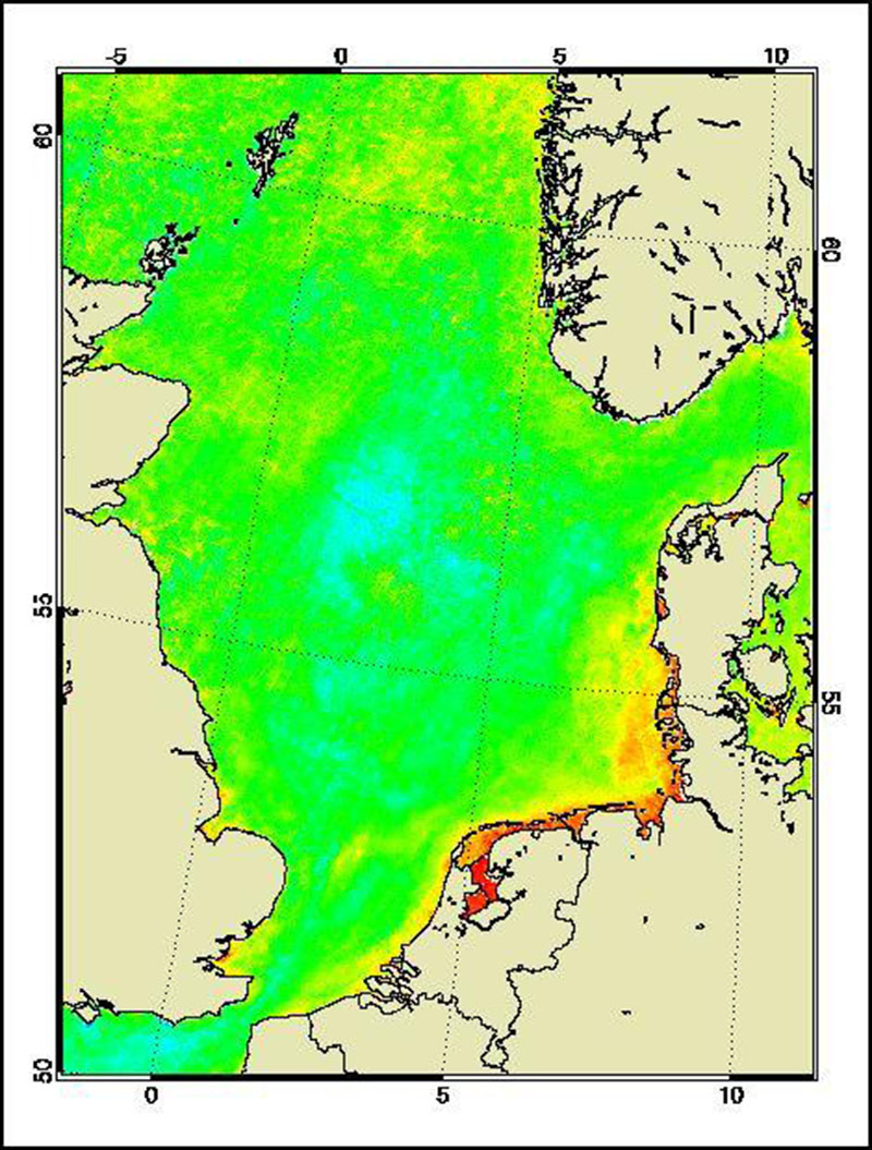
The Medium Resolution Imaging Spectrometer (MERIS) on Board ESA’s ENVISAT provides spectral high resolution image data in the visible-near infrared spectral region (412-900 nm) at a spatial resolution of 300 m. For more details on ENVISAT and MERIS see http://envisat.esa.int/ This product developed in the frame of the MAPP project (MERIS Application and Regional Products Projects) represents the chlorophyll concentration of the North Sea derived from MERIS data. The product is a cooperative effort of DLR-DFD and the Institute for Coastal Research at the GKSS Research Centre Geesthacht. DFD pre-processed up to the value added level whenever MERIS data for the North Sea region was received and positively checked for a water area large enough for a suitable interpretation. For more details the reader is referred to http://wdc.dlr.de/sensors/meris/ and http://wdc.dlr.de/sensors/meris/documents/Mapp_ATBD_final_i3r0dez2001.pdf This product provides 10-day maps.
-

The Medium Resolution Imaging Spectrometer (MERIS) on Board ESA’s ENVISAT provides spectral high resolution image data in the visible-near infrared spectral region (412-900 nm) at a spatial resolution of 300 m. For more details on ENVISAT and MERIS see http://envisat.esa.int/ This product developed in the frame of the MAPP project (MERIS Application and Regional Products Projects) represents the chlorophyll concentration of the North Sea derived from MERIS data. The product is a cooperative effort of DLR-DFD and the Institute for Coastal Research at the GKSS Research Centre Geesthacht. DFD pre-processed up to the value added level whenever MERIS data for the North Sea region was received and positively checked for a water area large enough for a suitable interpretation. For more details the reader is referred to http://wdc.dlr.de/sensors/meris/ and http://wdc.dlr.de/sensors/meris/documents/Mapp_ATBD_final_i3r0dez2001.pdf This product provides daily maps.
-

The Medium Resolution Imaging Spectrometer (MERIS) on Board ESA’s ENVISAT provides spectral high resolution image data in the visible-near infrared spectral region (412-900 nm) at a spatial resolution of 300 m. For more details on ENVISAT and MERIS see http://envisat.esa.int/ Spectral high resolution measurements allow to assess different water constituents in optically complex case-2 waters (IOCCG, 2000). The main groups of constituents are Chlorophyll, corresponding to living phytoplankton, suspended minerals or sediments and dissolved organic matter. They are characterised by their specific inherent optical properties, in particular scattering and absorption spectra. The Baltic Sea Water Constituents product was developed in a co-operative effort of DLR (Remote Sensing Technology Institute IMF, German Remote Sensing Data Centre DFD), Brockmann Consult (BC) and Baltic Sea Research Institute (IOW) in the frame of the MAPP project (MERIS Application and Regional Products Projects). The data are processed on a regular (daily) basis using ESA standard Level-1 and -2 data as input and producing regional specific value added Level-3 products. The regular data reception is realised at DFD ground station in Neustrelitz. For more details the reader is referred to http://wdc.dlr.de/sensors/meris/ and http://wdc.dlr.de/sensors/meris/documents/Mapp_ATBD_final_i3r0dez2001.pdf This product provides seasonal maps.
-

The Medium Resolution Imaging Spectrometer (MERIS) on Board ESA’s ENVISAT provides spectral high resolution image data in the visible-near infrared spectral region (412-900 nm) at a spatial resolution of 300 m. For more details on ENVISAT and MERIS see http://envisat.esa.int/ This product developed in the frame of the MAPP project (MERIS Application and Regional Products Projects) represents the chlorophyll concentration of the North Sea derived from MERIS data. The product is a cooperative effort of DLR-DFD and the Institute for Coastal Research at the GKSS Research Centre Geesthacht. DFD pre-processed up to the value added level whenever MERIS data for the North Sea region was received and positively checked for a water area large enough for a suitable interpretation. For more details the reader is referred to http://wdc.dlr.de/sensors/meris/ and http://wdc.dlr.de/sensors/meris/documents/Mapp_ATBD_final_i3r0dez2001.pdf This product provides monthly maps.
-
Schiffszählungen im Schleswig-Holsteinischen Wattenmeer 1991 und 1992 Punktecover
-

The AVHRR Mulitchannel Sea Surface Temperature Map (MCSST) was the first result of DLR's AVHRR pathfinder activities. The goal of the product is to provide the user with actual Sea Surface Temperature (SST) maps in a defined format easy to access with the highest possible reliability on the thematic quality. After a phase of definition, the operational production chain was launched in March 1993 covering the entire Mediterranean Sea and the Black Sea. Since then, daily, weekly, and monthly data sets have been available until September 13, 1994, when the AVHRR on board the NOAA-11 spacecraft failed. The production of daily, weekly and monthly SST maps was resumed in February, 1995, based on NOAA-14 AVHRR data. The NOAA-14 AVHRR sensor became some technical difficulties, so the generation was stopped on October 3, 2001. Since March 2002, NOAA-16 AVHRR SST maps are available again. With the beginning of January 2004, the data of AVHRR on board of NOAA-16 exhibited some anormal features showing strips in the scenes. Facing the “bar coded” images of NOAA16-AVHRR which occurred first in September 2003, continued in January 2004 for the second time and appeared in April 2004 again, DFD has decided to stop the reception of NOAA16 data on April 6th, 2004, and to start the reception of NOAA-17 data on this day. On April 7th, 2004, the production of all former NOAA16-AVHRR products as e.g. the SST composites was successully established. NOAA-17 is an AM sensor which passes central Europe about 2 hours earlier than NOAA-16 (about 10:00 UTC instead of 12:00 UTC for NOAA-16). In spring 2007, the communication system of NOAA-17 has degraded or is operating with limitations. Therefore, DFD has decided to shift the production of higher level products (NDVI, LST and SST) from NOAA-17 to NOAA-18 in April 2007. In order to test the performance of our processing chains, we processed simultaneously all NOAA-17 and NOAA-18 data from January 1st, 2007 till March 29th, 2007. All products are be available via EOWEB. Please remember that NOAA-18 is a PM sensor which passes central Europe about 1.5 hours later than NOAA-17 (about 11:30 UTC instead of 10:00 UTC for NOAA17). The SST product is intended for climate modelers, oceanographers, and all geo science-related disciplines dealing with ocean surface parameters. In addition, SST maps covering the North Atlantic, the Baltic Sea, the North Sea and the Western Atlantic equivalent to the Mediterranean MCSST maps are available since August 1994. The most important aspects of the MCSST maps are a) correct image registration and b) reasonable cloud screening to ensure that only cloud free pixels are taken for the later processing and compositing c) for deriving MCSST, only channel 4 and 5 are used.. The SST product consists of one 8 bit channel. For additional information, please see: https://wdc.dlr.de/sensors/avhrr/
-
INSPIRE theme Oceanographic Geographical Features.